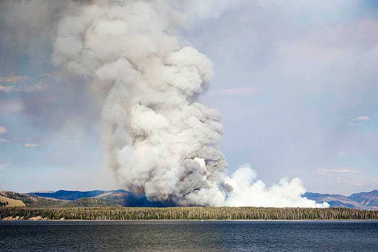
Hot, dry weather has persisted across the greater Yellowstone area as several lightning-caused fires continued to grow Tuesday. Yellowstone National Park officials have closed one popular roadside attraction and are making precautionary plans for the potential evacuation of visitors from Fishing Bridge and nearby areas, should the situation worsen.
The Alum Fire covers an estimated 4,500 acres, including a section that is burning within a mile from the Grand Loop Road south of Mud Volcano. The popular Mud Volcano, LeHardy Rapids, and several picnic areas and pullouts, as well as some backcountry trails in the area, are temporarily closed.
Park officials said there is the potential for temporary closures of the road between Canyon Village and Fishing Bridge.
While area closures are not imminent, preparations are underway to assist residents and visitors in leaving the Fishing Bridge, Lake Village and Bridge Bay area in the event that an evacuation is necessary in the coming days.
More firefighting personnel and equipment are arriving daily, with an estimated 150 fire personnel expected to be on hand in Yellowstone by Tuesday evening. Multiple structural and wildland fire engines and portable pumps and hoses are now located in the Lake, Fishing Bridge, and Bridge Bay area.
The Alder Fire burning near Yellowstone Lake has prompted park managers to close backcountry campsites along the Promontory, an area near where the 3,000-acre blaze is burning actively.
Park officials say the Alder Fire, burning on a peninsula at the south end of Yellowstone Lake, is hemmed in by water on three sides and by a recently burned area to the south.
The latest Yellowstone road status information is available 24-hours a day by calling 307-344-2117.
Teton Interagency Fire managers announced Tuesday that the fire danger rating has been elevated to “very high” for the Bridger-Teton National Forest, Grand Teton National Park and National Elk Refuge.
Fire officials warned that with exceptionally dry conditions, residents and visitors should practice heightened fire safety at all times.
Teton Interagency fire personnel have extinguished 125 unattended or abandoned campfires this summer, a near record number. Fire officals said that abandoned campfires can quickly escalate into wildfires, and it is extremely important that all campfires are completely extinguished and be judged cold to the touch before campers leave their site. The fine for an abandoned campfire is $225, but campers can also be held liable for suppression costs if their campfire becomes a wildfire.
Elsewhere in the Grand Teton area, the JDR fire was reported at approximately 4 p.m. Thursday and is burning four miles from Flagg Ranch in the John D. Rockefeller, Jr. Memorial Parkway.
The Observation Fire includes five spot fires burning within the Palisades Wilderness Study Area along the Caribou Targhee and Bridger Teton National Forests in the headwaters of Coulburn Creek, and at the head of the Little Dog and Dog Creek drainages.
The Snake Fire was reported August 5, burning actively 3 miles east of the south entrance to Yellowstone National Park on the border of the Bridger-Teton National Forest. Currently burning in heavy fuel loads of dead and down timber and a continuous stand of mixed conifers, the fire has spotted and moved on to the Bridger Teton National Forest.
Fire managers from the Yellowstone National Park and Teton Interagency fire are developing a management strategy.
The Moose fire is a 3-acre fire burning in Moose Basin in the upper end of Webb Canyon in Grand Teton National Park.
The Green Fire is located in the Upper Green River Valley on the Pinedale Ranger District. It is at the base of Osborn Mountain burning in heavy bug killed timber. The fire is currently 1,053 acres. Strategy will be to confine/contain with priority on keeping the fire south of the Roaring Fork drainage. The cause of this fire is lightning.
The Kendall Mountain Fire is a lightning caused fire was discovered August 3 on the Pinedale Ranger Station in the Upper Green. The fire is 196 acres burning in the Bridger Wilderness in rough, inaccessible terrain east of Boulder Basin.
South of Cody, Wyo., the Hardluck Fire covers approximately 24,000 acres, with work completed to reduce fuels and protect structures on Shoshone National Forest lands at the end of the South Fork Road.
An area closure is in effect for the entire South Fork drainage beginning south of Aspen Creek beyond the South Fork Road (County Road 6WX/Forest Service Road 479.B).
The lightning-caused Lost Lake Fire is burning 40 miles northwest of Cody and has grown to 50 acres since being discovered on Friday. Rugged terrain and concern for firefighter safety have limited firefighting operations to aerial resources and indirect tactics.
